DragonTail
Beneath my feet I could see the steep slope of the glacier
dropping straight down to gray dirty ice. My ice axe did little
other than to balance me, the tip wouldn't even bite into the
rock hard snow.  A slip here would be highly undesirable.
After my summer adventure in the Tetons, I had one last fall trip planned for October. I'd set the date for the second weekend in October and was trying to identify where to go. I'd narrowed it down to Black Peak up Maple Pass, Mt. Maude near the Icy Fingers Lakes or Dragontail in the Enchantments. With the weather so good, I took a Friday off the week before and headed up Sourdough in the North Cascades to Stetattle Ridge. That day could not have been more perfect. Having visited Highway 20 already, I felt drawn back to the Enchantments in the North Cascades.
Seth couldn't join me because it was his anniversary, but Jason Brown agreed to come along. The weather was gorgeous throughout the week but the forecast was deteriorating but I figured a day in the mountains even with rain was better than a day at work. I picked Jason up Friday morning at 5 am and we started up I-90, our first goal was permits at the ranger station in Leavenworth. I had only got around 4 hours of sleep the night before and I was still tired. I drove the first hour to Cle Elum and then Jason drove while I caught some sleep. We arrived at the Leavenworth Ranger Station at 7:15 and had a half hour to wait before they opened. I crossed the street to McDonald's and ordered some pancakes and eggs while Jason slept in the car. At 7:30 another truck pulled in with a man and woman and at 7:40 one more car pulled in with another party. At 7:44 the ranger came out and gave us some doom and gloom about the weather, how it was guaranteed to rain and we wouldn't see anything. Right at 7:45 she looked at her watch and said "well it's time. I pick you, and you and you" pointing to each of the three groups. No lottery, everyone got Enchantment Zone permits. We went inside to fill out paper work and pay our fees. At 7:46 another car drove up, doh! Not sure what permit he got but it pays to be on time.
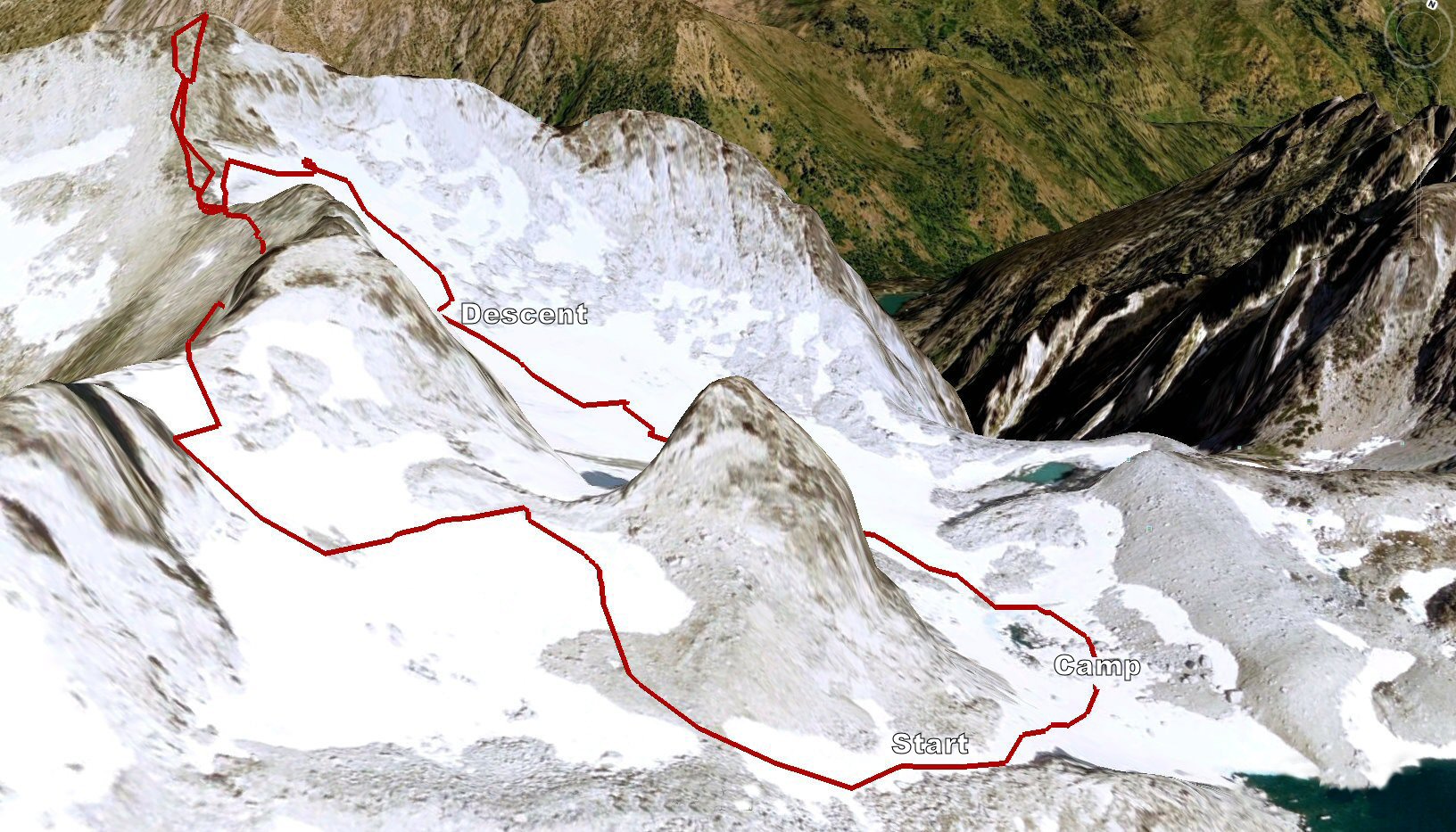
We drove up Icicle Creek Rd to Eightmile where we turned left and drove the 4 miles up to the Stuart/Colchuck trail head. Sorting gear, we hefted our packs and were off by 8:48 am. We kept a good pace up the trail, by 9:45 we were at the Stuart - Colchuck split and by 10:40 we were at Colchuck Lake. Instead of stopping we kept on going and by 11:00 we arrived at the end of the lake and the boulder field of rock that had fallen from the slopes of Dragontail and Colchuck over the eons. We quickly made our way across the boulders and by 11:30 we were at the base of Aasgard Pass. 2700 vertical feet of "trail" lay above us and we settled into a nice steady but not too fast pace of making our way up and up and up.
I told Jason there was a girl in the Enchantments who'd I'd never actually met but knew through nwhikers, Flickr and Facebook. Within 10 minutes of starting up I saw Jo descending in a party of four wearing her signature green hat. We greeted each other as we approached, shook hands and chatted for several minutes about the weather, hiking and photography. I snapped a photo of them and we parted; us up and them down.
As we approached the major stand of larch that sits halfway up Aasgard. What had been a very gray morning transformed as the sun burnt through the layer of clouds and shone down. The larch trees were lit by the edge of the sun, so that while the rest of the pass below them was covered in shadow they glowed as if full of yellow fire. We traversed below, around and above them admiring their full yellow color.
I really enjoy the upper half of Aasgard as it wends past waterfalls, and up through granite shoots, scraggly larch and finally the switchbacks near the top through boulders till you finally see the mighty Dragontail and the top. We arrived at 1:35pm; Jason was out if water and had a knot in his shoulder. I gave him some of my Gatorade and he sat down to rest while I climbed up the ridge towards Dragontail to look for camp and water. Spying some pools between Isolation Lake and Dragontail I motioned for him to follow. We made our way to a large pool of water that was just below Witches Tower west of the Snowcreek "glacier". We treated water and rehydrated and sat to eat our lunch. Once again Tim's Cascade Salt & Vinegar Chips hit the spot as did a bag of salmon and a McDonald's Chocolate Chip cookie I'd picked up that morning.
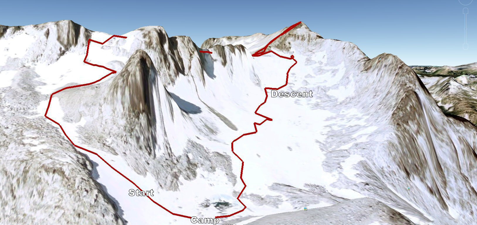
We found a spot for camp among the gravel that probably spent most of the year under snow and water but was bone dry in the between seasons. Jason was hurting, he was better after hydrating but still a bit sore. Our aim was Dragontail but given we knew weather was blowing in that night we'd talked about just going for it the same day. He was doubtful about being able to make it, but I encouraged him to at least give it a go and if we turned back no big deal. We emptied our packs, save for some water, a bit of food, a coat, shell and crampons. We donned our helmets and discussed routes. The most direct was the Snowcreek Glacier/snowfield but it looked like there was mostly just ice left and so we decided to try approaching from the ridge line further to the west. The route description called for gaining the ridge from the col between Little Annapurna and the west end of Dragontail's long ridge line. This would require us to swing way wide, but the snowfield just to the east of our camp looked like it would go.
We started up the snowfield, kicking steps in the hard névé; the slope quickly grew steeper and the snow harder. Too steep to put on crampons (which we should have started out in) I ended up chopping steps with my ice axe until we reached the first rock band where we could sit and don the crampons. Sharp points on your feet make the going so much easier, we settled into the rest step and plodded our way up. The snow ran out a hundred yards before the top of the ridge and we took off the sharpies and scrambled up the rock and gravel. At the top was a bowl with the proper ridge still ahead and above us several hundred feet higher, a smaller but easier attained ridge ran perpendicular to the main ridge to the rocky spire of Witches Tower. We hiked up to this cross ridge to peer back down a steep cliff into the far corners of Snowcreek snowfield. We descended back into the bowl and had two options : traverse farther east away from the summit to gain the ridge at the Little Anapurna col or head up a more direct small snow field and scramble some 50 feet of rock to the ridge. The question was the rock, but it looked like it might go, there were cliff bands and ledges.
We started up the snow field, staying close to rock ribs as we made our way up. I crossed the snow field (30 feet) cutting steps to the rock. There wasn't solid access to the rock at this point so Jason cut steps in the edge of the snow adjacent to the rock and climbed the snow to where we were able to easily gain the rock. From here Jason led up through the cliff bands via several fifth class moves; the exposure wasn't too intense, the holds were nice and big; slow and steadily we climbed. The last last 20 feet was an easy fourth class scramble to the top of the ridge. As you approach this kind of ridge line for the first time your never quite sure what lies on the other side? Will it cliff out and drop off? Thankfully we were on the ridge proper which was as described "surprisingly flat considering its craggy facade".
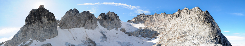
We walked along the ridges meadow and talus until we came to the col above the Snowcreek Glacier/snowfield. From here the summit is a walk up to the highest point. A small biivy spot sits just below the final summit stones. The rocky "dragon" spires of the ridgeline look south with Colchuck and Stuart in the beyond. We rested for a few minutes, posed for our summit shot and then started down. The day wasn't long left for light and we had a ways to go before dark. Given it was 5pm I was game to have a look at descending the Snowcreek Glacier. At the saddle, I jumped down onto the top of the snowfield to have a look. The slope was steep, there was lots of ice below, but there looked to be a line we could traverse. Jason really didn't want to even look, exasperatedly he jumped down onto the snow and peered over the edge. We agreed to swing to the left (west) end of the snowfield and descend to the rock and then make our circuitousness way down and as we got lower to head east toward camp.
I started out, stepping down onto the snow ridge and then onto the glacier. On gentler angles you can let the entire bottom of your crampon rest on the snow, but this angle was steep enough that you had to balance on just one edge of your crampons, with just two side points gripping. Beneath my feet I could see the steep slope of the glacier dropping straight down to gray dirty ice. My ice axe did little other than to balance me, the tip wouldn't even bite into the rock hard snow. A slip here would be highly undesirable. Slowly I carefully and gingerly put one foot in front of another, trusting the bite of the crampon. After several steps the intense concentration and having to hold my weight on the edges caused my legs to feel a bit wobbly. I finally reached the lip of the snow ledge; to my left was a 10 foot moat between the snow and the cliff wall of Dragontail and to the right the steep slope. I was able to sit down on the knife edge of the snow and scoot along; ignominious but safe I butt scooted until the ridge widened to a few inches and I was able to stand and tightrope walk the ridge to far side.
A natural melt path in the glacier had hardened in clear shiny ice but also littered the ice with gravel from the rock above. The crunchy gravel on the ice provide good grip and we slowly descended and then traversed around to the rock further down. Here I felt much better, the slope wasn't quite so steep and we could easily walk down either side-hilling or front facing down the slope. As we crossed the snow, rotten ice and rock the sun began to set and peaks of Dragontail and Witches Tower above us were stark sentinels of the darkening sky. You can see route details here and here.
We arrived in camp just with the last vestige of light beginning to fade. We put on headlamps and started setting up our tent. My new Vapor Light had a new pole design and it took a couple of tries to put it together. We staked out and guyed the tent and I put a pot of water on to boil for our dinners. I had the Pad See You with Chicken, which Seth had let me taste in the Tetons, delicious! We ate in the tent and after a few failed attempts to take a night photo I was ready for bed. It was 8:30 pm. We'd been up 14 hours, 2 driving and 8 and a half on the go. I was beat. We settled in and I feel asleep pretty quickly.
Sometime in the night the wind and rain began, morning found me at 5:50 when I woke up and typed a bunch of this report on my iPhone. We ate a bit of food, treated a little water, packed up our bags, rolled up the tent and were off by 8:30 am. As we descended Aasgard the rocks were popping and falling off of Dragontail. The fog was rolling across the lake below. A slight mist gave way to just fog and we took off layers; by 10 we were down to the lake. The trail went smoothly and quickly until the last 2 miles which seemed to drag on forever. The point when your feet start to ache from the pounding miles and the down, down, down. As we ran out of water, the muscles started cramping. I pulled out my GPS app and it said there was a 1000 yards left to the trail head. This didn't sound so bad until Jason realized that was a third of a mile. Finally we arrived at the end which had once been the start. I downed a liter of water, changed my clothes and we started the drive back home. Another great weekend in the mountains.
Video
Dragontail from mbgriffi on Vimeo.
Photos
www.flickr.com
|