"I spend so much of my life counting down the days until the next expedition...." Ben Saunders
"Inspiration. By inspiring ourselves we inspire others.... Please take this [inspiration] with you home and start gluing feathers to your arms and look at the world from a different perspective. And when you see mountains remember mountains can be moved." - Philippe Petit
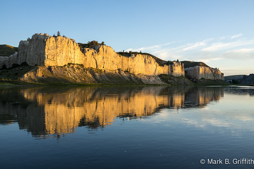
“As we passed on it seemed as if those seens of visionary inchantment would never have and end; for here it is too that nature presents to the view of the traveler vast ranges of walls of tolerable workmanship, so perfect indeed are those walls that I should have thought that nature had attempted here to rival the human art of masonry had I not recollected that she had first began her work.” - The Journal of Meriwether Lewis, May 31, 1805, describing the White Cliffs of the Missouri River
For a destination I needed to pick something that was an adventure, was in the wilderness and yet accessible without too much risk or effort (which is more mental maturity than capability for young boys).
Originally I was trying to put together a paddle trip to Shoshone Lake in Yellowstone with the Zollingers but when that didn't work I kept searching and somehow came upon paddling the White Cliffs section of the Upper Missouri River. This area is managed by the BLM and is 48 miles of river with no roads or bridges.
The Upper Missouri River offers adventure due to its remoteness. You have to drive 77 miles north out of Great Falls on a 2 lane road and then 8 miles down a dirt road to the put in at Coal Banks. Any time I've driven to the "end of the road" Ive found adventure waiting. (Shishi beach, Inner Mongolia, Yubeng). This section of the river is characterized by incredible rock formations : white limestone cliffs, dark rock dikes from ancient lava that squeezed between the limestone cracks and hoodoos with red iron tops. There is wildlife in abundance: nesting swallows, eagles, seagulls, pelicans, beavers, deer, raccoons, bats and coyotes. The river is surrounded outside these cliffs by farm and ranch land so you do see cows off and on when they have water access. But otherwise the landscape remains largely unchanged from when Lewis and Clark ascended the river on their transcontinental exploration in the early 1800s. The only thing missing from their time are the buffalo and the grizzly bears.

The next morning after a breakfast of oatmeal we loaded up our three canoes. Each carried a 5 gallon jug full of water. The Missouri is a muddy river known to clog filters and also contains the run off of pesticides and herbicides from the surrounding fields. There was that typical excited trepidation and wonder about the unknown before us as we settled into our canoe and paddled away from the bank.


Through out the course of our journey down the Missouri we saw 6 eagles, several deer on an island in the middle of water, multitude of pelican and heron, 100's of swallows, several bats at night when we also heard the coyotes howl.
Eagle Creek

Our first day we did 14.5 miles down to Eagle Creek, a long day. This campground was gorgeous. A large row of white cliffs line the southern bank across from you. Trees dot the base and along the top. A small canyon cuts a opening across from you flanked on one side by the dark brown lava dike known as Le Barge Rock in stark opposite to the white. Behind you the familiar stand of cottonwoods sit up on a bluff just above the flood zone. There are several fire rings and two pit toilets. We pitched our tents up behind the cottonwoods adjacent to a large field of sage and thickets.
As evening approaches the wind dies and the river goes flat and placid. The current also seemingly dissipated as if someone up stream had turned down the flow. The green water of the Missouri turns into a magical reflective mirror that you would not have guessed from the mid-days light and the semi dark flat green. As the sun sets across from you behind the cliffs the sky turns pink and cliffs at the north light up glowing white with the last evening sun.

For dinner we pulled out two still slightly frozen tri-tip which I cut into steaks. We used our band saw to cut a bunch of logs from a downed cottonwood and made a fire. Lowering the grill we cooked up the steaks. We were all starving and I would cut piping hot pieces of meat into bite size chunks and dole out the meat to the crew. Definitely agree one of the best steaks I've eaten. Pure carnivorous deliciousness.

As the sun set we relaxed around camp. The silence is almost deafening. The quiet of the place is a large part of its beauty and as Seth said : "my favorite part of sitting here is I have nothing I have to do". The morning is even more beautiful as the flat water reflects the cliffs across from you that glisten with the morning light. Morning doves coo and the flat calm of the river is occasionally broken by a jumping fish. Occasionally you hear cattle lowing in the distance and the high yip of a coyote.

As I reached our camp I saw again something leaving our shore and swimming for the other side. This time I was close enough to see it was a beaver who was coming over to gather willows before swimming back to his lodge on the opposite shore. I grabbed my tripod and Hope and walked south down the river to wait for the light to rise and make the white cliffs glow. I set up the tripod in a few feet of water and then noticed that the beaver was waddling up shore by our camp. I set my camera on interval shooting for every minute and grabbed my small Sony-RX1 and raced up the river behind the willows to see if I could get a better picture. He was already in the water when I ran out to the shore and as I ran into the water the beaver slapped his tail and dove under the surface. A few seconds later and he resurfaced with his willows still in his mouth heading for the far bank. Meanwhile the cliffs were gleaming a brilliant white reflecting in the calm river. You can see why the beauty captured Lewis and Clark as well as modern day paddlers who almost travel back in time.


Finally a fork in the canyon to the right immediately is a narrow slot canyon about 4 feet wide. The boys gleefully scampered up the narrow canyon, the white walls rising 30-40 feet above our heads. The first obstacle to be over come is 6 inch slot that you have to stem your way up. Hope could walk through the narrow opening but became wedged before she could climb up to the next level of the slot floor. I lifted her up and we kept winding our way up the canyon. Ancient boulders that had wedged in the mud that became sandstone bulged out of the wall as the softer sandstone had eroded. A myriad of small hollowed bowls dotted the walls of the canyon.
The second obstacle is a huge chockstone that has fallen and wedged itself in the slot blocking the way. You can climb under the boulder and wiggle up through a crawl way to the next level of the canyon. From here the canyon narrows and winds before suddenly widening and you reached the back end of the coulee. You can scramble up the white sandstone which is littered with dark iron rock that contrasts with the white. You can see a view from the top of the bluffs but the river is lost in the distance.

We broke camp, loaded up the canoes and set off down the river around 2:30. Our destination for the day was Hole in The Rock. Time paddling is broken up by finding interesting shapes among the hoodoos or the clouds. Of course the usual splashing of the guys in the other boats with paddles or even better with your bailing buckets.
Another past time on the Missouri is Moss Wars. The rocks are covered in green moss, which escapes the rocks and floats down stream. As your paddling large tumbling green moss strands will come bubbling to the surface. With a deft slice of your paddle you can gather a large pile and stockpile between your feet. Then you paddle like mad for a bombing run along side another canoe and you pummel each other with wet slimy balls of moss.
Hole in the Wall


There are two pit toilets, two lean-two with fire pits and a big grassy area. We had the entire place to ourselves! We hauled the gear up the bank and relaxed in the lean-twos as the sun set way down the river. From the bluff we could look up river from where we'd come and then out across the expanse. Dinner was roast beef sandwiches, slathered with yellow mustard with provolone chese, cucumber and avocados. Miles doesn't like any of that so I took a piece of steak left over from the night before, impaled it on a knife and heated it over the pocket rocket.

That evening the bugs were awful. I set up my Tri-pod to capture a sunset timelapse. I had to keep dancing around to keep the skeeters and biting horse flies from gnawing on me. After the sunset the light hangs on and on. We waited for the moon to come up trying to guess where it would it would rise above the ridge. I was too far to the right and was about to leave the camera running when Seth ran up asking if I could see the light shining behind the ridge. A huge orange moon peeked over the white cliff. One of the prettiest moon rises I've ever seen. Our luck in timing our trip with a full moon only added to the sweetness of the trip. None of my lenses did the sight any justice.
That night Miles and I slept with the top of the tent. Only the mesh protecting us from the horde of the mosquitos. You had to be careful not to rest your arms or legs against the mesh or they would bite you right through the tent. The full moon rode its nightime journey across the sky. Each time I would wake it was if someone had left the lights on. Around 3 am I woke to try a photo of the moon glow off the cliffs across the river. The moon was so bright I could see my moon shadow and walked down to the river without a headlamp.
At 5 am Seth and I woke to watch the sunrise, a long slow gradual brightening before the sun crested the ridge. Breakfast was bacon, eggs and huckleberry pancakes with syrup. We had a long day ahead of us and we packed up before setting down the river around 9:30. This section below Hole in the Wall had spectacular hoodoos and rock formations. Organ pipes, dark Sith Lords watching on the hillside, the dark butte and the seven sisters. Around 11 an we stopped at mile 66.5 at The Walls where we pulled out of the river and sat among the grass and flowers under a huge Cottonwood tree that had been partially chopped through but was still alive. Miles and Ben went down to the river to play and Miles got stuck in the mud again. I pulled him free with a paddle and we washed him off and set down the river again. We still had 11 miles to paddle and the scenery went from fascinating to the banal sage brush hills. The river winds back and forth and you keep rounding point after point. The sun was hot and the boys were tired, soon each one had laid down in the front of the canoe. The adults all paddled and Miles and Hope slept. I pulled out my Bluetooth jambox speaker and played some music from my iPhone. The Shins, Radiohead, The Head and the Heart serenaded us as we paddled and battled the wind.
Slaughter Creek
The wind was nice to keep the heat down a little but if you didn't keep the bow directly into the wind your canoe would catch like a sail and you'd be blown to the left or the right. Finally we pulled around the last bend and came upon Slaughter Creek camp, named by Lewis and Clarke for the huge pile of dead buffalo they saw at the mouth of the creek on their journey to the Pacific. The river is not too wide here and a big long wall of cliffs, the last on the river, sit across from the camp. Big huge cottonwood trees line the bank 6-7 feet above the river. These were the biggest trees I had seen along the river.The sound of the wind blowing through the cottonwood leaves, a gentle rustling that soothed us while we cooked up a dinner of beef sausage, rigatoni pasta and spaghetti sauce with some cheese. We went for a swim after dinner and played moss wars in the Missouri current. Later that night just an hour before sunset the wind picked up to 30 miles an hour kicking up white caps on the river. Eventually we got lightening and thunder and even after we fell asleep a few drops of rain.
The next morning, our last on the river, Seth and I again woke early to watch the sun rise. We caught the pre-dawn glow and then started rousing the boys at 6 am. They mumbled and fumbled through packing up as the light hit the cliffs. Seth and I took another round of photos and as the sun broke through the cottonwoods my big camera's battery died.
We had a no cook breakfast and managed to load up and be on the water by 7:30 am. We were at mile 66.5 and the take out at Judith's Landing was 84.5, so we only had 8 miles to go. Of at least that is how I calculated it. After 7 miles we all talked excitedly about how close we were but bend after bend turned to 8, then 9 and then 10 miles. I wondered if something was off on my GPS. Then as we passed mile 11 I realized I'd done the math wrong and instead of 8 we had 18 miles to go. As I bemoaned the bad news to the rest of the gang we were all sad about another 7 miles.
Just then a kayaker paddled up and asked how we were doing. I explained fine until we realized we had a lot further to go. He said where you headed? Judith Landing. "Well that is only 12 miles from where you camped?" Unbelievably out sadness was gone and the next bend the bridge came into view and we were done. I still don't get how 66 to 84 is 12, but it ain't 8 either.
We unloaded gear and packed up canoes and found out cars that had been driven in by Don at Virgelle Mercantile and then drive the very long 44 miles down a dusty dirt road back to pavement and headed back toward Great Falls. Along the way we stopped at Loma's Cafe for burgers and shakes. (The Big Sky Burger is huge!) Great ending to a great trip.
This adventure surpassed my expectations. The scenery was far better and more beautiful than I had expected. I loved playing in the river, as did Miles. And I loved being out with good friends and my son. There were many magical moments, those times when your surreally aware of the amazing nature of what your doing. Almost out of an out of body awareness. I've already started thinking about next year.
Planning your Trip
Anyone can do this trip. You can take a guided trip with the Missouri River Canoe Company where they provide everything, canoes, gear, food all you have to do is show up and paddle. Or you can do it by your own means as we did.Here are the logistics, (map showing detail about the trip : www.google.com/maps/ms?msid=217880351927118169121.0004dae...)
- Day 0 arrive sleep over at Coal Banks : 77 miles north of Great Falls Montana
- Day 1 paddled 5.44 miles to Sandy Banks - get out and hike up to bluff
- Day 1 paddle 9 miles to Eagle Creek - spend night
- Day 2 hike 3 miles up and back to Neat Coulee adjacent to Eagle Creek
- Day 2 paddle 7.5 miles to Hole in the Wall
- Day 2/3 (we missed it, too tired, too long a day - hike up to Hole in the Wall) ]
- Day 3 paddle 14 miles to Slaughter Creek
- Day 4 paddle 12 miles to take out at Judith Landing
- Total : 51.15 miles
Gear
- Three Canoes, PFDs and paddles- each had an adult and 1 boy; one had a dog as well
- One cooler to keep the fresh food fresh
- One container with dry food
- Lots of dry bags to stuff everything in
- Everyone brought : tent, sleeping pad, sleeping bags
- Folding camp chairs - (we sat in ours while we paddled, nice back support)
- Miles and I also had inflatable sit pads from REI to sit on, an extra bit of cushion 5
- 5 gallons of water per canoe - plus each canoe had a nalgene bottle at the front and back to sip on during the day
- lots of sun
- block bug spray
- floppy hat to keep sun off you
- clothes line - to hang the wet stuff at days end
- hiking shoes + socks
- chaco or keen sandals
- solar charger - to keep the iPhone charged
- first aid kit (Seth cut his finger)
- Bucket Toilet - wag bags and TP : you have to carry your waste out, but we always stayed at sites with pit toilets and never used it.
- 2 Stoves - plus 2 bottles of fuel
- One GSI mess kit with pots and pans, plates and cups
- knife & utensils
- small cutting board
- foldable saw for firewood
- cameras
- tri-pod
VIDEO
Photos
Upper Missouri River - July 2013 from mbgriffi on Vimeo.www.flickr.com
|