Location: Mt. Diablo. Trailhead at the end of Regency Road in Clayton.
Elevation Start/End: ? / ? feet. (540 elevation gain)
Length: 4.2 miles round trip
Trail Info: This follows Donner Canyon road up to Donner Canyon where several small waterfalls cascade over the rocks.
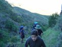
The scouts needed more conditioning hikes in preperation for the 50 miler. We planned on for Saturday morning. It had been raining off and on this past week, so Friday afternoon Sofi and I drove out to the trail head to see the conditions. Things looked fine so we hiked up to the falls at Donner Canyon on Saturday.
Click a picture to see a larger view.